 In general about Mt. Pilio
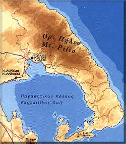
Pilio lies on a peninsula of the prefecture of Magnisia extending southeast of Volos towards the Sporades islands. Its northern boundaries touch the Volos-Keramidi axis whereas its south end reaches down to Argalasti. It is ca. 44 kn in length and its width varies between 10 kn in the south and 25 km in the north. Its highest peak, at 1.624 m., is not accessible sdue to military installations.
The mountain is densely wooded all over, the vegetation being far from the typical found elsewhere in Greece. Beeches, oak-trees, apple-trees and wild chestnut-trees from shadowy forests which cover the mountain from end to end. There is water streaming everywhere all year long, even in midsummer. In winter, it is often covered with snow, despite its low height, and there's even a ski resort in Chania.
Hiking in Pilio
More than 500 km of paths, trails and tracks offer many opportunities for walking in Pilio. There used to be a network of old cobbled trails linking the villages, but unfortunately these have been largely destroyed by the far too many bulldozers appearing in every corner of the mountain. However, there still remain many to hike on. The featured routes are not particularly demanding for a hiker in good physical condition. However, if you are not an experienced hiker it's better to attempt some short hikes first, to check on your abilities. The routes suggested here run mostly on well preserved cobbled trails or mountain paths with only very small stretches of dirt tracks or asphalt.
The routes suggested by Road Editions are 4:
- Kala nera - Milies
- Milies - Tsangarada
- Across Tsangarada
- Tsangarada - Damouchari.
We present here the second one, being the most "mountaineering".
General gear
Regardless of the time of year, you should always have trekking boots on and it is also advisable to be in long pants. A small backpack with water and something to eat will offer you more freedom in your excursions. Sun glasses and a hat are also needed in summer for extra protection.
Attention! These routes can become very difficult and possibly impassable in winter when there is snow. If weather conditions are bad, only experienced climbers should attempt them.
Milies - Tsangarada
-
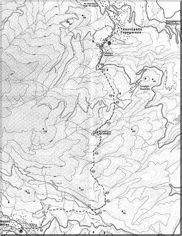
Track: Milies Tsangarada - designed by Antonis Kalogirou.
This is a 10 km-long route with an elevation gain of 420 m, which is highly recommended, if you do not tire easily. You will walk through amazing scenery, the highlight being a wonderful beech forest which takes on a different appearance each season of the year. Should you come here in autumn, you'll be rewarded by the sight of leaves turning to create a feast of colours.
You will arrive in Tsangarada after 4 hours, passing its arched bridge amidst luxuriant growth. The route runs for its most part on a cobbled trail, making it even more charming. You'll get a spectacular view of the Aegean sea from high up.The "statistics" of the route
- Kilometres: 10
- Hours: 4
- Bearing: 30ο
- Elevation gain of ascent: 450 μ.
- Elevation loss of descent: 310 μ.
- Lowest point: 360 μ.
- Highest point: 770 μ.
- Vegetation: *****
- Fountain: Yes
- Condition of ground: cobbled trail, mountain path, dirt track, asphalt
- Way marking: * (red marks)
Description
We are at the main Square of milies facing the entrance of the church of Agios Taxiatchis. Behind the church to the north we can see the library of the village . On the right side of the library is the start of the cobbled trail leading to Tsangarada. Once on the cobbled trails we follow a 110ο bearing.
After 8 minutes
After 300 m there's a concrete drive goind off to the right, whereas the cobbled trail goes to left. We stick to the cobbled trail, which is lost then found again.After 15 minutes
After 300 m (bearing 60ο) we reach a U-shaped concrete road. We follow its left arm, which soon turns into a dirt track, then into concrete again and winds uphill.After 23 minutes
After 300 m the dirt track turns left but we follow the path to the right, which soon becomes a cobbled trail lined with cypresses on its right side. There is an irrigation ditch on our left.After 25 minutes
After 100m. we cross a stream on a small concrete bridge. We walk along the stream's edge keeping a 60ο bearing. We go past a cobbled trail going left. Our trail turns into a narrow dirt track. We have walked 1,4 km along the stream. We go past a water tank on our right.After 1 hour and 03 minutes
We have reached a junction where many dirt tracks meet. We choose the one immediately left to the one we just quit. Right after, we turn left to a main dirt road (bearing 320ο). We go past a dirt track on our right.After 1 hour and 10 minutes
After 200 m we come to a fork. But, looking to our right we'll see a second dirt track running parallel to our own. This is the one we'll follow by turning right and heading east. We walk through a chestnut wood. We reach a crossing and we continue straight on, heading north.After 1 hour and 32 minutes
After 300m. the dirt track ends and turns into a cobbled trail going north.After 1 hour and 55 minutes
After 1 km the trail curls and is now heading west, following the mountain's relief. The trail hides in a magnificent beech forest (beech is a deciduous tree). We are at the highest point of the route. We go downhill on a cobbled trail.After 2 hours and 25 minutes
After 300m. we go past a trail on our right and carry on. After 500 m. we have reached a gully (dry in summer) which we cross and walk on. The cobbled trail soon turns into a narrow dirt track. 400 m. past the gully we quit the dirt track which turns left and we take the trail to the right going downhill (heading east).After 2 hours and 55 minutes
After 900m. the trail takes us to a point where a concrete drive and a dirt track meet in U-shape. We follow its left arm and right after we reach a fork. We go right upwards and get to the country church of Agios Dimitrios. We continue on the dirt road, heading north.After 3 hours and 05 minutes
After 400 m. we take the right side of the forkAfter 3 hours and 15 minutes
After 400 m. at a right turn we go downwards a shortcut (the road is beneath us). After a 150 m we rejoin the track and we go left.After 3 hours and 20 minutes
After 150 m. we come to a fork; the concrete drive to the right leads to Xourichti whereas the one on the left takes us to the back of a house (there is a large wooden pavillion in the backyard). We walk past the back of the house and after 200 m. we go past a water tank on our left and carry on on an overgrowth trail.After 3 hours and 35 minutes
After 600 m. we have reached the main asphalt road of Tsangarada and we follow it to the left. At 100 m, just before a right turning of the asphalt, a trail descends steeply (on a 320ο bearing). We pass an old small arched bridgeAfter 3 hours and 45 minutes
We hit the asphalt again, we go right . The first houses of Tsangarada come into sight (the Agion Taxiarchon district).After 3 hours and 55 minutes
After 400 m. we get to a fountain with refreshing cool water. Map
-